Posts

Showing posts from August, 2020

Resume tips for Aircraft Technician.

Image
 ' Resume' is a reflection of your personality and attitude. 1.Resume should not be more than two pages. Human resources department don't have enough time to look at your huge menu cards , so make it simple. 2. You should not write on the heading as  resume or curriculum vitae . Instead of that write your full name in bold.    3.Highlight your educational achievements as per company requirement. e.g. Passed paper 1 & 2. 3. On the Second page, at the bottom, there should be your personal information. Following information should be there : Your full name    Email id     Date of Birth   Permanent address.   Contact number and alternate contact number.   Aadhar card and passport number . 4.Photo should be there in the first page. 5.Resume should be updated regularly . 6.Font size should be between 11 to 14 clearly . Do not use cursive font. 7.Cover letter should  always be address to HR manager . 8. There should be 1 inch space around each page of resume. 9. The resume pap

The historic Decca/ VLF Omega navigation

Image
Conventional VOR/DME have one disadvantage in that they are land base and unable to navigate over coastal region. Long-range radio navigation system based on hyperbolic navigation where introduce in the 1940's to provide for en-route operations over oceanic and on populated areas.  Several hyperbolic system have been deployed  since, including Decca, omega and LORAN-C.  The operational use of omega and decca navigation system ceased in 1997 and 2000 respectively. And it was replaced by GPS and INS system. LORAN - C system are still very much available today as stand-alone system, they are also being proposed as a complimentary navigation aid for GPS.  the LORAN-C system is based on a master station and a numbers of secondary stations(slave), the use of very low frequency radio provides increased area of coverage.   Frequency : very low frequency (vlf) 10 -14 khz. System consists of ground-based fix master and several slave stations  (located at different location). OMEGA/ DECCA

How do the fighter planes jettison?

Image
Dumping fuel from the aircraft (in flight)  is called jettisoning. On ground , it is called defuelling. Fighter planes are capable of refulling  in flight.Since commercial passenger aircraft carries passenger, they are not allowed to refuel during flight due to safety reasons. More ever, commercial planes have very big fuel tanks(in their wing) so they don't require in flight  refueling.They always carry additional fuel for holding or taxing. Every commercial pilot calculates their  usable fuel in his plane in the following manner : Departure to  Destination + 30 minute extra (for holding and taxing). If an aircraft has to do 'air turn back' (return to airport ) then the aircraft has to dump certain amount of fuel which is called jettisoning. It is calculated by flight management computer and executed by the pilot's manually   Pilots cannot dump fuel anywhere, they have to take permission from air traffic controllers.  after that they (ATC) will inform a specific area w

How to avoid 'a window seat without window'?

Image
We travel through bus, train or plane, we always look for a window seat so that we can enjoy the glimpse of the nature.   Nowadays, through web check in, we can choose our favorite seat. Some  passenger like window seat while some like aisle seat. But, if you are travelling on an airplane, there is something that you should always be very careful - it is called a 'window seat without a window '. Yes! It may sound weird, but it does exist.  This is because some electrical vertical conduits pass from that area. Unfortunately, if you select this seat through web check in or normal check in on the airport, then your journey will be a nightmare for you. There are some tactics through which you can prevent this seat being selected by you. So, Whenever you select a seat always check aircraft configuration. You can do it through the company website or in seat guru website.  Look for a special colors. If you find a red color on the window seat, then you aren't supposed to select tho

GLONASS(Russian global navigation system)

Image
Selective availability of GPS   : GPS included a feature called selective availability that adds intentional, time varrying errors up to 10 metre horizontal and 30 metres vertically into the publicly available L1 signal. This was intended to deny an enemy the use of civilian GPS receiver for precision weapon guidance. The GPS can be used for the following purposes. 1. Differential GPS (DGPS) : for marine uses, maintained by the US coast guard. 2.WAAS (wide area of mentation system) . Extremely accurate navigation system developed by FAA. Provide service for all aircraft for all phase of the flight including and route navigation, airport departure and arrival. Particularly LNAV & VNAV in  low visibility operations. Currently,it only covers North america as there are no ground reference stations for this technology in other countries yet. 3.LAAS ( local area augmentation system)  all weather aircraft landing system (instrument landing system) used to replace conventional ground bas

Global Positioning System : working

Image
GPS Operations: 1.The property of wave propagation can be used for satellite navigation purpose in the. 2. First, we need to know the exact position of satellite in orbit about the earth. 3.When the satellite transmitts radio wave to an observer on the earth surface  , the time delay between when the radio signal was transmitted and received provides the means of calculating the spherical range between the satellite and observer. 4.  Through second satellite, we can improve directional ambiguity.  5. Third satellite will improve all directional ambiguity and define our 2D dimensional position on the earth. 6. Fourth satellite will give us the 3D view as well as Latitude and longitude and altitude. 7.Once  the user's position has been calculated, the gps receiver can derive additional useful navigation information track,ground speed and drift angle. Space segment : Each satellite is installed with the ' four atomic clock' that are extremely accurate, typically maintai

Global positioning system(GPS)

Image
  1.Global positioning system(GPS) was invented in 1973 by United State Military , and referred to as ' Navstar'(navigation satellite with the timing and ranging ). 2.The system was initially developed for use by the us military. They were using this  satellite for surveillance purpose on neighboring countries. 3.The first satellite was launched in 1978 and full constellation was in place and operating by 1994 . 4. GPS is now widely available for use by many applications including aircraft navigation. 5. The system compromises a space segment, user segment and control segment .  6.The  control segment  consist of ground based transrecivers which monitors the satellite health.e.g. NASA, ISRO. 7.The  user segment  can be an Aircarft, any personnel. 8.The  space segment  consist of group of 24 Satellite. 9. 24 satellite (the space segment )in orbit around the earth send data via radio link that allows aircraft receivers (the user segment) to calculate precise position, altit

Parallel career in Aircraft maintenance

Image
The aviation industry is considered as the most glamorous industry in the world.   All of us, are always attracted toward its brightness. Airlines employees are always well groomed and airport area is always a fascinated area for us. In short, we all want to work on the airport, but due to the lack of guidance, we fails to enter into the aviation. In this blog, you will get detailed knowledge about 'how to enter in various departments of airlines'.  1. Planning department : this department co-ordinates between maintenance activity and quality control department. They make sure that all planned maintenance activity is properly supported with the tools/ parts/ consumables.  Qualification: AME / Degree . How to apply: through the company website. 2. Quality control department :  this department keeps proper record of all maintenance work done on the aircraft. All original paper like C of C, calibration certificate, employee qualification certificates are kept in original format. Q

Fighter Pilot's Kneeboard

Image
The cockpit of fighter plane is very small and congested. Also fighter pilot has to carry extra accessories like helmet,G-suit, Guns etc. So their hands are generally very buisy . Only thing that is available is the knee area where they attach their all required documents , while walking towards their Aircarft. The area which holds the paper is called ' Kneeboard' . The kneeboard held their maps, local airfield approach charts and radio frequencies, and miscellaneous information about that particular mission. That's probably all integrated into the heads up display, HUD, now, but guys probably still carry back up charts in case of HUD failure. There are generally two types of check list 1. CCL : also called cockpit check list , for normal operation of the aircraft. 2. ECL : emergency check list: which is used while emergency.Along with this some other important documents are attached to their kneeboard.  Cockpit of a Lockheed C-141 Starlifter A kneeboard is an accessory (

LNAV( lateral navigation ) & VNAV( vertical navigation)

Image
RNAV  is a short form of  Area Navigation . LNAV and VNAV are parts of the automatic flight director system(AFDS), and are short form for ' lateral navigation ' and ' Vertical Navigation'.  1.LNAV  :is the route you fly over the ground or simply lateral movement of the aircraft w.r.t ground. The plane may be using VORs, GPS, DME, or any combination of the above. As pilot enters his route as specified in the FMS (Flight Management System). The route shows up as a magenta line on the lower flight display, and as long as the autopilot is engaged in the LNAV mode, it will follow that line across the ground. LNAV however does not tell the plane what altitude to fly. 2.VNAV  means guidance to the pilot w.r.t to descent or climb or in simple words vertical movement of the aircraft. If you are flying with the autopilot on in VNAV mode at cruise altitude, you can enter what speed you desire to make a descent at, and what altitude you wish to cross a particular point, and the

Aircraft model & series number.

Image
Aircraft model number designates, the family to which it belongs. e.g. Narrow body 737 Or Wide body 777. Series number indicates speciality of that particular aircraft. If you want to know the detail about any particular model like,  flying range , size ,capacity then you should focus on its series number .Some airlines modify their aircraft as per their operational experience and it is called ' retrofitting '. Retrofitting includes(but not limited) activity like reshaping fuselage size, fitting diffrent engines of same thrust rating or modifying cabin layout.'Retrofited' aircraft again  have a unique series number like B747 300 SP (Special performance) . This B747SP was made for (short range minimum fuel and maximum passenger capacity).  Fig 1 :B747SP(Special perfomance) B 747 is a family and it has hundreds of sub-models, retrofitted. While writing,e.g. B737-800NG,   we can use very intelligent method which saves our time and space.It is written as ' B738 '

Area Navigation (RNAV)

Image
       Area Navigation (RNAV) Until 1960-70, very few airlines used to operate in the world. Because of that airspace was not much congested. Getting approved to fly on a specific route was very easy. Aircrafts were getting departure and arrival clearance at  very short period time due to low air traffic.  In such cases it was possible to fly with minimum ground based navigation aids e.g. VOR, DME. Fig 1: aircraft flying from VOR to VOR. As time passes, policies like 'Open sky' changed the future of aviation. More and more airlines started operating(even with the few aircrafts). Due to this, airspace started to become more and more occupied. RNAV is short for 'Area Navigation '. In the old days you used to have to fly directly over the navigation aids on the ground (VOR, NDB etc) to make your route. It meant a slightly zig-zag course for your flight as you couldn't get the navaids in a perfect line between every possible city pair. Then when computers started gettin

Aircraft Special operation codes.

Image
Commercial Aircraft can be used for special purpose (other than passanger ) under following codes. ATC gives permission for intended flight through FIC number(Flight plan ). 1. HEAD : flight for head of state 2. STATE  : military/customs or police service 3.SAR : search and rescue  4.NON - RVSM : non- rvsm  aircraft to operate in rvsm airspace . 5.MEDEVAC :critical medical evacuation. 6.MARSA :Military operation 7.HUM : humanitarian mission 8.HOSP :  medical flight declared by medical operatives. 9.HAZMAT :  for carrying hazardous material.e.g. lithium ion battery. 10.FLTCHK : flight for calibration of navigation aids. 11.FFR : Firefighter services 12.ALTRV: Air space utilisation under prescribed condition normally employed for mass moment of the aircraft.

Doppler navigation 3 : Airborne equipement.

Image
 Airborne equipement . 1. Doppler navigation system uses directional beams to derive ground speed and drift as previously described this beams are arranged in a number of ways.  2.The fore and aft beam are referred to as ' Janus ' configuration (after the roman god of openings  And beginning, Janus, we could face in two directions at the same time).   3.Three beams can be arranged in the form of greek letter lambda.  4.The four beam arrangement in an X-configuration, only three beams are actually required,the  fourth provides a level of monitoring and redundancy.  5.In the four beam arrangement, the fore and aft signals are transmitted in alternative pairs. 6. In the four beam arrangement, the fore and aft signals transmitted in alternative pairs. Referring to the relationship:                F D =2cos Ѳ x vf / c F D: frequency diffrence Ѳ : the angle between the beam and aircraft  V=aircraft velocity f=frequency of transmission. C=speed of light 7. Frquency allocated is 13.25-

Doppler Navigation Part 2 : Problems &solutions

Image
The signal-to-noise ratio of the received signal is a function of number of factors including  : 1.Aircraft range to the terrain. 2.Backscattering feature of the terrain. 3.Atmospheric conditions,I.e. attenuation and absorption of radar energy. 4.Radar equipment. Problem 1 :             Fig:1 pitch up and down calibration. If the aircraft where pitched up or down, this would change the angle of the beam with respect to the aircraft and the surface, this will change the value of doppler shift for a given ground speed.  This situation can be overcome in one of two ways, the transmitter and receiver can be mounted on a stabilized platform or (more usually ) Two beams can be transmitted from the aircraft (forward and aft ) ,as shown in the figure.  Problem 2 : When flying over oceans, the Doppler system will calculate velocity  that include movement of the sea due to tidal effect i.e. not a true calculation of speed over the earth's surface. The short-term error will be average out ove

Doppler Navigation system

Image
1.Doppler navigation is a self-contained dead reckoning system i.e. it required no external inputs or reference from ground stations . 2. Ground speed and drift can be determined using a fundamental scientific principle called dop pler shift . 3.Doppler navigation system were developed in the mid 1940 and introduce in the mid 1950 as a primary navigation system with many features including continuous calculation of ground speed and drift being self contain the system can be used for long distance navigation over oceans and undeveloped areas of the globe  . 4.Doppler sensors are used in other specialised airborne applications, including  Weather radar and missile warning system . and has VOR ground installation also incorporate doppler principle . 5.The doppler effect is name after christian doppler   ( 1803-1853 )  An austrian mathematician and physicist. his hypothesis was that the frequency of a wave apparently changes as it source moves closer to, for further away from, an obser

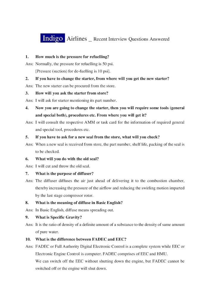
INDIGO AIRLINES AMT INTERVIEW QUESTION PAGE 5

Image

INDIGO AIRLINES AMT INTERVIEW QUESTION PAGE 4

Image

INDIGO AIRLINES AMT INTERVIEW QUESTION PAGE 3

Image

INDIGO AIRLINES AMT INTERVIEW QUESTION PAGE 2

Image

INDIGO AIRLINES AMT INTERVIEW QUESTION PAGE 1

Image